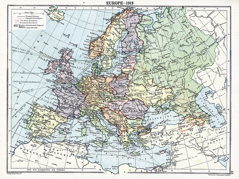
Immaggine:Europe map 1919.jpg

Dimenscioìn de st'anteprìmma chi: 800 × 600 pixel. Âtre resoluçioìn: 320 × 240 pixel | 640 × 480 pixel | 1 024 × 768 pixel | 1 280 × 960 pixel | 1 920 × 1 440 pixel.
File òriginâle (1 920 × 1 440 pixel, dimensción do file: 1,41 MB, tîpo MIME: image/jpeg)
Cronologîa do file
Sciàcca in sce 'n grùppo dæta/ôa pe védde comm'o l'êa o file into moménto indicòu.
| Dæta/Ôa | Miniatûa | Dimenscioìn | Uténte | Coménti | |
|---|---|---|---|---|---|
| prezénte | 07:41, 7 agó 2023 |  | 1 920 × 1 440 (1,41 MB) | User-duck | Cropped to reduce border using CropTool with lossless mode. |
| 01:29, 23 arv 2008 |  | 1 996 × 1 506 (1,39 MB) | File Upload Bot (Magnus Manske) | {{BotMoveToCommons|en.wikipedia}} {{Information |Description={{en|Map of en:Europe political divisions in 1919 (after the treaties of Brest-Livotsk and Versailles and before the treaties o |
Utilìzzo do file
A pàgina chi de sótta a contêgne di ligàmmi a sto file chi:
Utilìzzo globâle do file
Quésto file o l'é dêuviou da 'ste âtre wiki ascì:
- Dêuviòu inte pàgine de anp.wikipedia.org chi de sótta:
- Dêuviòu inte pàgine de ar.wikipedia.org chi de sótta:
- Dêuviòu inte pàgine de azb.wikipedia.org chi de sótta:
- Dêuviòu inte pàgine de az.wikipedia.org chi de sótta:
- Dêuviòu inte pàgine de be.wikipedia.org chi de sótta:
- Dêuviòu inte pàgine de ca.wikipedia.org chi de sótta:
- Dêuviòu inte pàgine de cs.wikipedia.org chi de sótta:
- Dêuviòu inte pàgine de da.wikipedia.org chi de sótta:
- Dêuviòu inte pàgine de el.wikipedia.org chi de sótta:
- Dêuviòu inte pàgine de en.wikipedia.org chi de sótta:
- Dêuviòu inte pàgine de eo.wikipedia.org chi de sótta:
- Dêuviòu inte pàgine de es.wikipedia.org chi de sótta:
- Dêuviòu inte pàgine de et.wikipedia.org chi de sótta:
- Dêuviòu inte pàgine de fi.wikipedia.org chi de sótta:
- Dêuviòu inte pàgine de fr.wikipedia.org chi de sótta:
- Dêuviòu inte pàgine de ga.wikipedia.org chi de sótta:
- Dêuviòu inte pàgine de hi.wikipedia.org chi de sótta:
- Dêuviòu inte pàgine de hu.wikipedia.org chi de sótta:
- Dêuviòu inte pàgine de hy.wikipedia.org chi de sótta:
- Dêuviòu inte pàgine de id.wikipedia.org chi de sótta:
- Dêuviòu inte pàgine de it.wikipedia.org chi de sótta:
- Dêuviòu inte pàgine de ko.wikipedia.org chi de sótta:
- Dêuviòu inte pàgine de la.wikipedia.org chi de sótta:
- Dêuviòu inte pàgine de mai.wikipedia.org chi de sótta:
- Dêuviòu inte pàgine de mk.wikipedia.org chi de sótta:
Véddi l'ûzo globâle de quésto file.


