
Immaggine:Reliefkarte Malta.png

Dimenscioìn de st'anteprìmma chi: 645 × 600 pixel. Âtre resoluçioìn: 258 × 240 pixel | 516 × 480 pixel | 826 × 768 pixel | 1 131 × 1 052 pixel.
File òriginâle (1 131 × 1 052 pixel, dimensción do file: 443 KB, tîpo MIME: image/png)
Detàggi
| Descriçión |
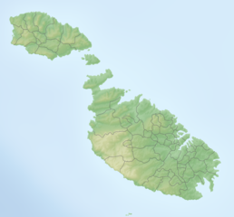
Deutsch: Reliefkarte Malta
Topographischer Hintergrund: NASA Shuttle Radar Topography Mission (public domain). SRTM3 v.2. |
||||||||
| Dæta | |||||||||
| Vivàgna | Òpera pròpia | ||||||||
| Aotô | Tschubby | ||||||||
| Licénsa (Dêuviâ tórna 'sto file chi) |
Mi, detentô di driti d'aotô de st'œuvia, deciæo de pubricâla sotta-e seguente lisensie:
Questo file è disponibile in base alle licenze Creative Commons Attribuzione-Condividi allo stesso modo 2.5 Generico, 2.0 Generico e 1.0 Generico
Ti ti pêu çèrne a licénsa che ti ti vêu. |

Cronologîa do file
Sciàcca in sce 'n grùppo dæta/ôa pe védde comm'o l'êa o file into moménto indicòu.
| Dæta/Ôa | Miniatûa | Dimenscioìn | Uténte | Coménti | |
|---|---|---|---|---|---|
| prezénte | 09:25, 6 lùg 2019 | | 1 131 × 1 052 (443 KB) | Toghrul R | aspect ratio fix to match svg version |
| 09:05, 5 màz 2018 |  | 1 172 × 1 052 (423 KB) | Tschubby | == {{int:filedesc}} == {{Information |Description= {{de| Reliefkarte Malta}} Topographischer Hintergrund: [http://www2.jpl.nasa.gov/srtm NASA Shuttle Radar Topography Mission] (public domain). SRTM3 v.2. |Source={{own}} |Date= 2018-05-05 |Author= Tschubby |Permission= {{self|GFDL|Cc-by-sa-3.0-migrated|Cc-by-sa-2.5,2.0,1.0}} |other_versions= }} Category:Location maps of Malta |
Utilìzzo do file
A pàgina chi de sótta a contêgne di ligàmmi a sto file chi:
Utilìzzo globâle do file
Quésto file o l'é dêuviou da 'ste âtre wiki ascì:
- Dêuviòu inte pàgine de az.wikipedia.org chi de sótta:
- Dêuviòu inte pàgine de bg.wikipedia.org chi de sótta:
- Dêuviòu inte pàgine de cv.wikipedia.org chi de sótta:
- Dêuviòu inte pàgine de da.wikipedia.org chi de sótta:
- Dêuviòu inte pàgine de de.wikipedia.org chi de sótta:
- Malta
- Comino
- Cominotto
- Saint Paul’s Islands
- Filfla
- Ġgantija
- Sender Cyclops
- Ta’ Dmejrek
- Vorlage:Positionskarte Malta
- Ramla Bay (Gozo)
- Wikipedia:Kartenwerkstatt/Positionskarten/Europa
- Anchor Bay (Malta)
- Megalithische Tempel von Malta
- Chadwick Lakes
- Fungus Rock
- Santa Verna
- St Thomas Tower
- St Mary’s Tower
- Blaue Lagune (Malta)
- St Anthony Battery
- Daħlet Qorrot
- Għar ta’ Għejżu
- Gozokanal
- Santa Marija Battery
- Benutzer:Tschubby/Reliefkarten
- Mistra Battery
Véddi l'ûzo globâle de quésto file.