
Immaggine:East Germany 1956-1990.svg

Dimensción de quest'anteprìmma PNG pe sto file chi SVG: 450 × 456 pixel. Âtre resoluçioìn: 237 × 240 pixel | 474 × 480 pixel | 758 × 768 pixel | 1 011 × 1 024 pixel | 2 021 × 2 048 pixel.
File òriginâle (file into formâto SVG, dimenscioìn nominâli 450 × 456 pixel, dimenscioìn do file: 474 KB)
Detàggi


.svg)
.svg)
.svg)
.svg)
.svg)


.svg)
.svg)
.svg)


.png)
.png)


.svg)


.svg)

.svg)


.svg)
.svg)
.svg)
.svg)


.svg)
.png)


.svg)


.svg)
.svg)


.svg)


.svg)


.svg)
.svg)
.svg)
.svg)
.svg)
.svg)
.svg)
_cropped.svg)
.svg)
.svg)
.svg)
.svg)
.svg)
.svg)
.svg)
.svg)
.svg)
.svg)
.svg)
.svg)
.svg)
.svg)
.svg)
.svg)
.svg)
.svg)
.svg)
.svg)
.svg)
.svg)
.svg)
.svg)
.svg)
.svg)
.svg)
.svg)
.svg)
.svg)
.svg)
.svg)
.svg)
.svg)
.svg)
.svg)
.svg)
.svg)
.svg)
.svg)
.svg)
.svg)
.svg)
.svg)
.svg)
| Questa è una immagine ritoccata, il che significa che è stata modificata digitalmente dalla sua versione originale. Modifiche: {{{1}}}. La versione originale può essere vista qui: Blank map of Europe 1956-1990.svg.
|
Licénsa
Mi, detentô di driti d'aotô de st'œuvia, deciæo de pubricâla sotta-a seguente lisensia:
Quésto file o l'é rilasciòu sott'a-i tèrmini da licénsa Creative Commons Atribuçión-Condivìddi a-o mæximo mòddo 3.0 Unported
- Ti t'ê lìbero:
- de condivìdde – de copiâ, distriboî e trasmétte 'st'òpera chi
- de modificâ – de adatâ l'òpera
- A-e condiçioìn chi de sótta:
- atribuçión – Ti ti dêvi atriboî a paternitæ de l'òpera, indicâ o link a-a licénsa, e indicâ se són stæti fæti di cangiaménti ascì. Ti ti pêu fâ coscì inte 'n mòddo raxonévole e de mòddo da no sugerî che quélli ch'à dæto a licénsa sostêgnan ti ò a manêa inta quæ ti t'adêuvi l'òpera.
- condivìddi a-o mæximo mòddo – Se ti càngi, trasfórmi ò svilùppi o materiâle ti dêvi distriboî i tò contribûti segóndo 'na licénsa pægia ò conpatìbile a l'òriginâle.
Registro do caregamento originâ
This image is a derivative work of the following images:
- File:Blank_map_of_Europe_1956-1990.svg licensed with Cc-by-sa-3.0
- 2011-10-30T04:43:42Z Alphathon 450x456 (485146 Bytes) == {{int:filedesc}} == {{Information |Description={{en|Blank map of Europe showing national borders as they stood from 1956-1990.}} |Source=*[[:File:Blank_map_of_Europe.svg|]] |Date=2011-10-30 04:42 (UTC) |Author=*[[:File:Bla
Cronologîa do file
Sciàcca in sce 'n grùppo dæta/ôa pe védde comm'o l'êa o file into moménto indicòu.
| Dæta/Ôa | Miniatûa | Dimenscioìn | Uténte | Coménti | |
|---|---|---|---|---|---|
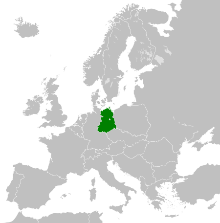
| prezénte | 02:33, 26 nov 2011 | | 450 × 456 (474 KB) | StalwartUK | == {{int:filedesc}} == {{Information |Description={{en|Map of the East Germany (German Democratic Republic) as it was from 1949-1990. Surrounding countries accurate from 1956-1990.}} |Source=*[[:File:Blank_map_of_Europe_1956-1990.svg| |
Utilìzzo do file
A pàgina chi de sótta a contêgne di ligàmmi a sto file chi:
Utilìzzo globâle do file
Quésto file o l'é dêuviou da 'ste âtre wiki ascì:
- Dêuviòu inte pàgine de af.wikipedia.org chi de sótta:
- Dêuviòu inte pàgine de am.wikipedia.org chi de sótta:
- Dêuviòu inte pàgine de an.wikipedia.org chi de sótta:
- Dêuviòu inte pàgine de ar.wikipedia.org chi de sótta:
- Dêuviòu inte pàgine de ast.wikipedia.org chi de sótta:
- Dêuviòu inte pàgine de azb.wikipedia.org chi de sótta:
- Dêuviòu inte pàgine de az.wikipedia.org chi de sótta:
- Dêuviòu inte pàgine de ba.wikipedia.org chi de sótta:
- Dêuviòu inte pàgine de be.wikipedia.org chi de sótta:
- Dêuviòu inte pàgine de bs.wikipedia.org chi de sótta:
- Dêuviòu inte pàgine de ca.wikipedia.org chi de sótta:
- Dêuviòu inte pàgine de ce.wikipedia.org chi de sótta:
- Dêuviòu inte pàgine de cs.wikipedia.org chi de sótta:
- Dêuviòu inte pàgine de de.wikipedia.org chi de sótta:
- Dêuviòu inte pàgine de de.wiktionary.org chi de sótta:
- Dêuviòu inte pàgine de diq.wikipedia.org chi de sótta:
- Dêuviòu inte pàgine de el.wikipedia.org chi de sótta:
- Dêuviòu inte pàgine de en.wikipedia.org chi de sótta:
- Dêuviòu inte pàgine de en.wiktionary.org chi de sótta:
- Dêuviòu inte pàgine de eo.wikipedia.org chi de sótta:
- Dêuviòu inte pàgine de es.wikipedia.org chi de sótta:
- Dêuviòu inte pàgine de es.wiktionary.org chi de sótta:
- Dêuviòu inte pàgine de eu.wikipedia.org chi de sótta:
- Dêuviòu inte pàgine de ext.wikipedia.org chi de sótta:
- Dêuviòu inte pàgine de fa.wikipedia.org chi de sótta:
- Dêuviòu inte pàgine de fi.wikipedia.org chi de sótta:
- Dêuviòu inte pàgine de fr.wikipedia.org chi de sótta:
- Dêuviòu inte pàgine de fr.wiktionary.org chi de sótta:
- Dêuviòu inte pàgine de ga.wikipedia.org chi de sótta:
- Dêuviòu inte pàgine de gd.wikipedia.org chi de sótta:
- Dêuviòu inte pàgine de gl.wikipedia.org chi de sótta:
- Dêuviòu inte pàgine de gv.wikipedia.org chi de sótta:
- Dêuviòu inte pàgine de he.wikipedia.org chi de sótta:
- Dêuviòu inte pàgine de hi.wikipedia.org chi de sótta:
- Dêuviòu inte pàgine de hr.wikipedia.org chi de sótta:
- Dêuviòu inte pàgine de hr.wiktionary.org chi de sótta:
- Dêuviòu inte pàgine de hsb.wikipedia.org chi de sótta:
- Dêuviòu inte pàgine de hu.wikipedia.org chi de sótta:
- Dêuviòu inte pàgine de hy.wikipedia.org chi de sótta:
- Dêuviòu inte pàgine de ia.wikipedia.org chi de sótta:
- Dêuviòu inte pàgine de id.wikipedia.org chi de sótta:
- Dêuviòu inte pàgine de is.wikipedia.org chi de sótta:
- Dêuviòu inte pàgine de it.wikipedia.org chi de sótta:
Véddi l'ûzo globâle de quésto file.