
Immaggine:Map Anatolia ancient regions-en.svg

File òriginâle (file into formâto SVG, dimenscioìn nominâli 921 × 596 pixel, dimenscioìn do file: 256 KB)
| Descriçión |
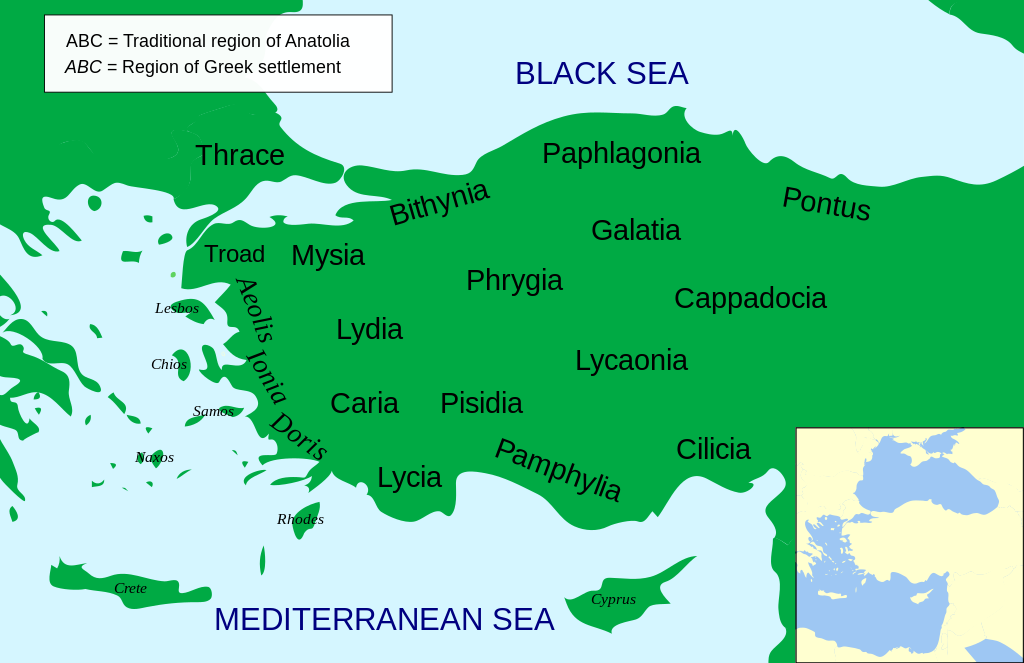
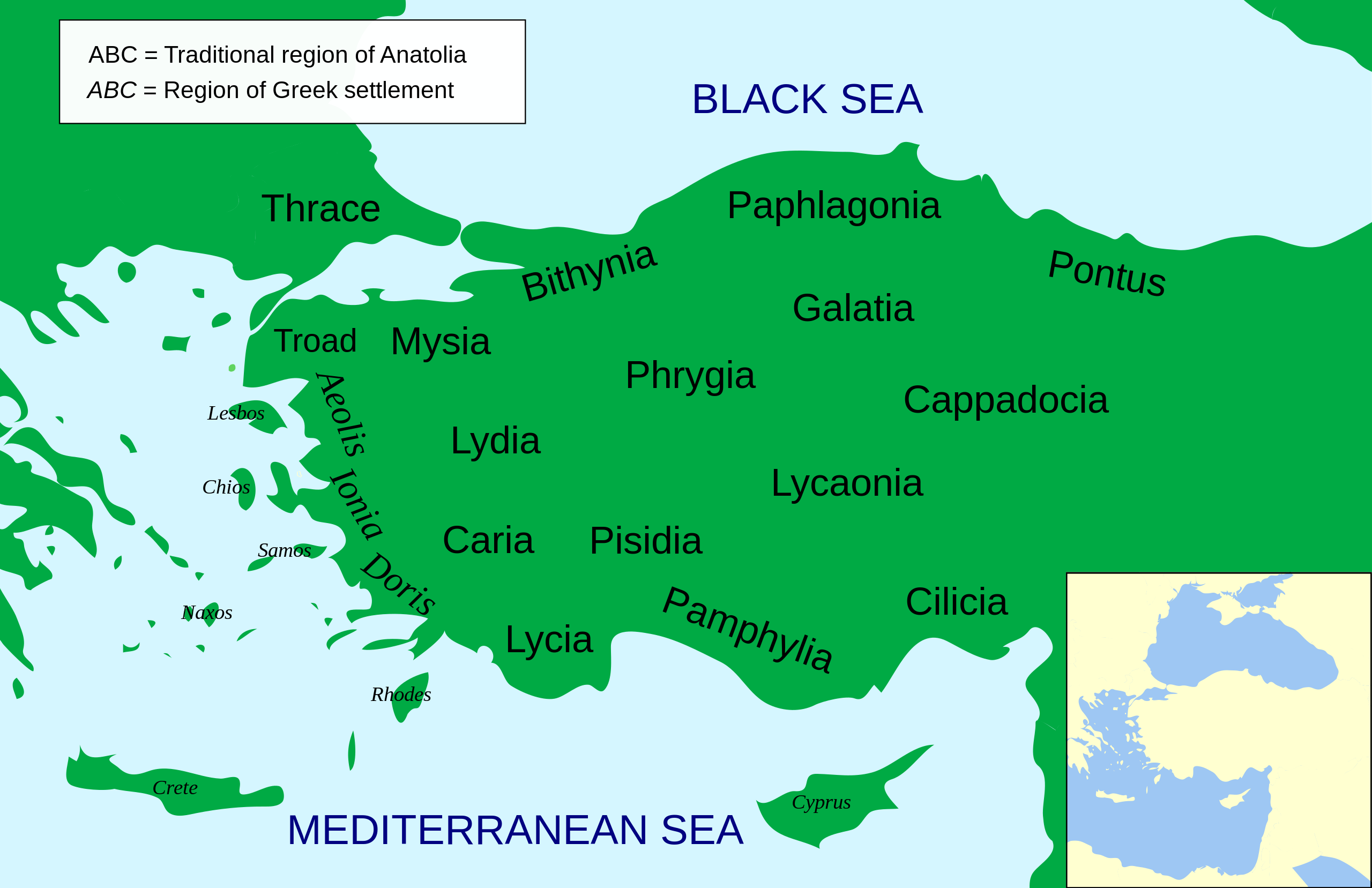
Català: Mapa regional d'Àsia Menor al segle II aC
English: Regional map of Asia Minor in the 2nd Century BC |
| Dæta | (UTC) |
| Vivàgna | |
| Aotô |
|
| Atre verscioin |
Other related versions: []
Opere derivate da questo file: |


.svg)


|
Questo file SVG contiene del testo che può essere facilmente tradotto nella tua lingua, utilizzando un editor che supporta SVG (ad esempio un editor XML o di testo). Per maggiori informazioni vedi: Tradurre un file SVG. |
This file is translated using SVG For most Wikipedia projects, you can embed the file normally (without a To translate the text into your language, you can use the SVG Translate tool. Alternatively, you can download the file to your computer, add your translations using whatever software you're familiar with, and re-upload it with the same name. You will find help in Graphics Lab if you're not sure how to do this. |
| Questa è una immagine ritoccata, il che significa che è stata modificata digitalmente dalla sua versione originale. Modifiche: Increased legibility, slight corrections in position. La versione originale può essere vista qui: Asia Minor Political 500BC.svg. Le modifiche sono di MinisterForBadTimes.
|
- Ti t'ê lìbero:
- de condivìdde – de copiâ, distriboî e trasmétte 'st'òpera chi
- de modificâ – de adatâ l'òpera
- A-e condiçioìn chi de sótta:
- atribuçión – Ti ti dêvi atriboî a paternitæ de l'òpera, indicâ o link a-a licénsa, e indicâ se són stæti fæti di cangiaménti ascì. Ti ti pêu fâ coscì inte 'n mòddo raxonévole e de mòddo da no sugerî che quélli ch'à dæto a licénsa sostêgnan ti ò a manêa inta quæ ti t'adêuvi l'òpera.
- condivìddi a-o mæximo mòddo – Se ti càngi, trasfórmi ò svilùppi o materiâle ti dêvi distriboî i tò contribûti segóndo 'na licénsa pægia ò conpatìbile a l'òriginâle.

|
O l'é permìsso copiâ, distriboî e/ò modificâ 'sto papê chi in bâze a-i tèrmini da GNU Free Documentation License, Versción 1.2 ò sucesîva, publicâ da-a Free Software Foundation; sénsa de seçioìn no modificàbili, sénsa tèsto de covertìnn-a e sénsa tèsto de quàrta de covertìnn-a. Ina còpia da licénsa a l'é inclûza inta seçión intitolâ Tèsto da GNU Free Documentation License. |
Registro do caregamento originâ
This image is a derivative work of the following images:
- File:Asia_Minor_Political_500BC.svg licensed with Cc-by-sa-3.0, GFDL
- 2009-04-22T07:38:42Z MinisterForBadTimes 921x596 (283615 Bytes) Coloured in rogue region
- 2009-04-22T07:36:20Z MinisterForBadTimes 921x596 (283353 Bytes) Changed fonts...again
- 2009-04-22T07:33:39Z MinisterForBadTimes 921x596 (283414 Bytes) Changed fonts
- 2009-04-22T07:25:50Z MinisterForBadTimes 921x596 (284262 Bytes) {{Information |Description={{en|1= Political map of Asia Minor in 500 BC}} |Source=*[[:File:Mysia.svg|]] |Date=2009-04-22 08:23 (UTC) |Author=*[[:File:Mysia.svg|]]: [[User:Emok|Emok]] *derivative work: *[[:Image:Mysia_map_anc
Uploaded with derivativeFX
Cronologîa do file
Sciàcca in sce 'n grùppo dæta/ôa pe védde comm'o l'êa o file into moménto indicòu.
| Dæta/Ôa | Miniatûa | Dimenscioìn | Uténte | Coménti | |
|---|---|---|---|---|---|
| prezénte | 16:14, 15 fre 2024 | | 921 × 596 (256 KB) | Manlleus | File uploaded using svgtranslate tool (https://svgtranslate.toolforge.org/). Added translation for ca. |
| 16:01, 15 fre 2024 |  | 921 × 596 (235 KB) | Manlleus | fixed text labels for translation | |
| 21:48, 23 arv 2009 |  | 921 × 596 (278 KB) | MinisterForBadTimes | Added Galatia, minor other changes | |
| 18:01, 22 arv 2009 |  | 921 × 596 (277 KB) | MinisterForBadTimes | {{Information |Description={{en|1= Political map of Asia Minor in 500 BC}} |Source=*File:Asia_Minor_Political_500BC.svg |Date=2009-04-22 17:00 (UTC) |Author=*File:Asia_Minor_Political_500BC.svg: *Mysia.svg: [[User:Emok|Emok |
Utilìzzo do file
A pàgina chi de sótta a contêgne di ligàmmi a sto file chi:
Utilìzzo globâle do file
Quésto file o l'é dêuviou da 'ste âtre wiki ascì:
- Dêuviòu inte pàgine de af.wikipedia.org chi de sótta:
- Dêuviòu inte pàgine de als.wikipedia.org chi de sótta:
- Dêuviòu inte pàgine de am.wikipedia.org chi de sótta:
- Dêuviòu inte pàgine de ar.wikipedia.org chi de sótta:
- Dêuviòu inte pàgine de azb.wikipedia.org chi de sótta:
- Dêuviòu inte pàgine de az.wikipedia.org chi de sótta:
- Dêuviòu inte pàgine de be-tarask.wikipedia.org chi de sótta:
- Dêuviòu inte pàgine de bg.wikipedia.org chi de sótta:
- Dêuviòu inte pàgine de bn.wikipedia.org chi de sótta:
- Dêuviòu inte pàgine de br.wikipedia.org chi de sótta:
- Dêuviòu inte pàgine de bs.wikipedia.org chi de sótta:
- Dêuviòu inte pàgine de ca.wikipedia.org chi de sótta:
- Dêuviòu inte pàgine de cs.wikipedia.org chi de sótta:
- Dêuviòu inte pàgine de da.wikipedia.org chi de sótta:
- Dêuviòu inte pàgine de de.wikipedia.org chi de sótta:
- Dêuviòu inte pàgine de diq.wikipedia.org chi de sótta:
- Dêuviòu inte pàgine de en.wikipedia.org chi de sótta:
Véddi l'ûzo globâle de quésto file.