
Immaggine:Relief Map of Armenia.png
Dimenscioìn de st'anteprìmma chi: 585 × 599 pixel. Âtre resoluçioìn: 234 × 240 pixel | 469 × 480 pixel | 1 000 × 1 024 pixel.
File òriginâle (1 000 × 1 024 pixel, dimensción do file: 1,73 MB, tîpo MIME: image/png)
Detàggi
| Descriçión |
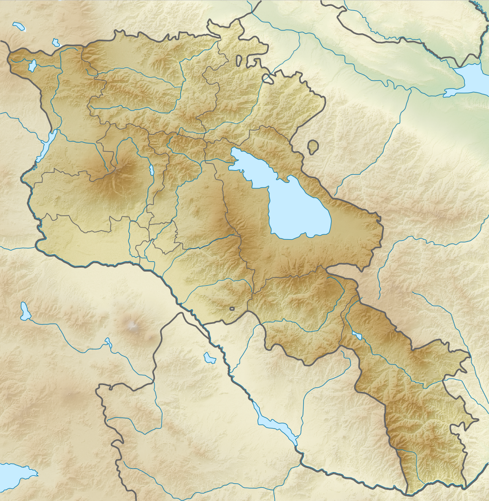
English: Relief map of Armenia. Equirectangular projection, N/S stretching 130 %. Geographic limits of the map:
Français : Carte topographique de l'Arménie. Projection cylindrique équidistante, avec étirement nord-sud de 130%.
|
| Dæta | |
| Vivàgna | |
| Aotô |
|
| Licénsa (Dêuviâ tórna 'sto file chi) |
Quésto file o l'é rilasciòu sott'a-i tèrmini da licénsa Creative Commons Atribuçión-Condivìddi a-o mæximo mòddo 3.0 Unported
|
Cronologîa do file
Sciàcca in sce 'n grùppo dæta/ôa pe védde comm'o l'êa o file into moménto indicòu.
| Dæta/Ôa | Miniatûa | Dimenscioìn | Uténte | Coménti | |
|---|---|---|---|---|---|
| prezénte | 20:21, 22 fre 2014 | | 1 000 × 1 024 (1,73 MB) | A2D2 | No unilateral changes. International borders are used. Please create additional svg map. |
| 11:21, 21 fre 2014 |  | 585 × 599 (654 KB) | Հայկ Ափրիկյան | Added Artsakh. | |
| 21:49, 5 arv 2012 |  | 1 000 × 1 024 (1,73 MB) | Sémhur | Adding few rivers : Dzoraget, Aghstafa, Azat, Vedi and Megri | |
| 21:36, 26 agó 2010 |  | 1 000 × 1 024 (1,73 MB) | Виктор В | == {{int:filedesc}} == {{Information |Description={{en|Relief map of Armenia}} Equirectangular projection, N/S stretching 130 %. Geographic limits of the map: * N: 41.4° N * S: 38.8° N * W: 43.4° E * E: 46.7° E |Source=*[[:File:Armenia |
Utilìzzo do file
A pàgina chi de sótta a contêgne di ligàmmi a sto file chi:
Utilìzzo globâle do file
Quésto file o l'é dêuviou da 'ste âtre wiki ascì:
- Dêuviòu inte pàgine de ar.wikipedia.org chi de sótta:
- Dêuviòu inte pàgine de ast.wikipedia.org chi de sótta:
- Dêuviòu inte pàgine de av.wikipedia.org chi de sótta:
- Dêuviòu inte pàgine de azb.wikipedia.org chi de sótta:
- Dêuviòu inte pàgine de az.wikipedia.org chi de sótta:
- Ağçala dağı
- Göyçə gölü
- Şablon:Yer xəritəsi Ermənistan
- Zəngiçay
- Alagöz dağı
- Loru çökəkliyi
- Ləlvar dağı
- Qazangöl (Ermənistan)
- Şəki şəlaləsi
- Dilijan Milli Parkı
- Göyçə yarımadası
- Ardanış yarımadası
- Goravan səhrası
- Tej-əhməd dağı
- Kari gölü
- Arpi gölü
- Şikahoğ Dövlət Təbiət Qoruğu
- Erebuni Dövlət Təbiət Qoruğu
- Mehri SES
- Göyçə-Zəngi kaskadı
- İrəvan Dəmiryol Stansiyası
- Gümrü Dəmiryol Stansiyası
- Xosrov Dövlət Təbiət Qoruğu
- Göyçə Milli Parkı
- İrəvan Botanika Bağı
- Ağrı vadisi
- Şərqi Göyçə silsiləsi
- Nərədüz burnu
- Balıqlı (göl)
- Apaklu
- Qarnıyarıq dağı
- Bərgüşad kaskadı
- Bərgüşad silsiləsi
- Qılıncdağ
- Abaran (yaylaq)
- Ajdaak vulkanı
- Geğam silsiləsi
- Qanlı göl (Göyçə)
- Axuryan su anbarı
- Lecan dağı
- Gərni dərəsi
- İrəvan zəlzələsi (1679)
- Dêuviòu inte pàgine de ba.wikipedia.org chi de sótta:
Véddi l'ûzo globâle de quésto file.