
Immaggine:Republic of Venice 1789.svg

Dimensción de quest'anteprìmma PNG pe sto file chi SVG: 450 × 456 pixel. Âtre resoluçioìn: 237 × 240 pixel | 474 × 480 pixel | 758 × 768 pixel | 1 011 × 1 024 pixel | 2 021 × 2 048 pixel.
File òriginâle (file into formâto SVG, dimenscioìn nominâli 450 × 456 pixel, dimenscioìn do file: 927 KB)
Detàggi


.svg)
.svg)
.svg)
.svg)
.svg)


.svg)
.svg)
.svg)


.png)
.png)


.svg)


.svg)

.svg)


.svg)
.svg)
.svg)
.svg)


.svg)
.png)


.svg)


.svg)
.svg)


.svg)


.svg)


.svg)
.svg)
.svg)
.svg)
.svg)
.svg)
.svg)
_cropped.svg)
.svg)
.svg)
.svg)
.svg)
.svg)
.svg)
.svg)
.svg)
.svg)
.svg)
.svg)
.svg)
.svg)
.svg)
.svg)
.svg)
.svg)
.svg)
.svg)
.svg)
.svg)
.svg)
.svg)
.svg)
.svg)
.svg)
.svg)
.svg)
.svg)
.svg)
.svg)
.svg)
.svg)
.svg)
.svg)
.svg)
.svg)
.svg)
.svg)
.svg)
.svg)
.svg)
.svg)
.svg)
.svg)
Licénsa
Mi, detentô di driti d'aotô de st'œuvia, deciæo de pubricâla sotta-a seguente lisensia:
Quésto file o l'é rilasciòu sott'a-i tèrmini da licénsa Creative Commons Atribuçión-Condivìddi a-o mæximo mòddo 3.0 Unported
- Ti t'ê lìbero:
- de condivìdde – de copiâ, distriboî e trasmétte 'st'òpera chi
- de modificâ – de adatâ l'òpera
- A-e condiçioìn chi de sótta:
- atribuçión – Ti ti dêvi atriboî a paternitæ de l'òpera, indicâ o link a-a licénsa, e indicâ se són stæti fæti di cangiaménti ascì. Ti ti pêu fâ coscì inte 'n mòddo raxonévole e de mòddo da no sugerî che quélli ch'à dæto a licénsa sostêgnan ti ò a manêa inta quæ ti t'adêuvi l'òpera.
- condivìddi a-o mæximo mòddo – Se ti càngi, trasfórmi ò svilùppi o materiâle ti dêvi distriboî i tò contribûti segóndo 'na licénsa pægia ò conpatìbile a l'òriginâle.
Registro do caregamento originâ
This image is a derivative work of the following images:
- File:Europe_1789.svg licensed with Cc-by-sa-3.0
- 2013-04-14T03:44:26Z Alphathon 450x456 (858577 Bytes) Corrected some errors in northern Italy
- 2013-04-14T01:38:01Z Alphathon 450x456 (853881 Bytes) tweaked again
- 2013-04-14T01:36:10Z Alphathon 450x456 (853881 Bytes) Tweaked Holy Roman Empire border style
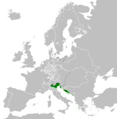
- 2013-04-14T01:33:26Z Alphathon 450x456 (853857 Bytes) == {{int:filedesc}} == {{Information |Description={{en|A blank Map of Europe circa 1789. This map also includes a border for the [[:en:Holy Roman Empire|Holy Roman Empire]]. Since there are so many small German states, they h
Uploaded with derivativeFX
Cronologîa do file
Sciàcca in sce 'n grùppo dæta/ôa pe védde comm'o l'êa o file into moménto indicòu.
| Dæta/Ôa | Miniatûa | Dimenscioìn | Uténte | Coménti | |
|---|---|---|---|---|---|
| prezénte | 00:20, 27 nov 2021 | | 450 × 456 (927 KB) | Cplakidas | Fixing Venetian Albania, adding Cythera to Venice |
| 09:55, 17 òtô 2021 |  | 450 × 456 (803 KB) | Fenn-O-maniC | Fixed the Russo-Swedish border to match the Treaty of Åbo of 1743 | |
| 11:23, 27 fre 2020 |  | 450 × 456 (821 KB) | Facquis | Clear map | |
| 19:16, 18 arv 2013 |  | 450 × 456 (820 KB) | Alphathon | Various fixes | |
| 05:54, 14 arv 2013 |  | 450 × 456 (802 KB) | Alphathon | == {{int:filedesc}} == {{Information |Description={{en|A map of the Republic of Venice circa 1789.}}{{de|Eine Landkarte die Republik Venedig c. 1989.}} |Source={{Derived from|Europe_1789.svg|display=5... |
Utilìzzo do file
A pàgina chi de sótta a contêgne di ligàmmi a sto file chi:
Utilìzzo globâle do file
Quésto file o l'é dêuviou da 'ste âtre wiki ascì:
- Dêuviòu inte pàgine de azb.wikipedia.org chi de sótta:
- Dêuviòu inte pàgine de bg.wikipedia.org chi de sótta:
- Dêuviòu inte pàgine de ca.wikipedia.org chi de sótta:
- Dêuviòu inte pàgine de ckb.wikipedia.org chi de sótta:
- Dêuviòu inte pàgine de cs.wikipedia.org chi de sótta:
- Dêuviòu inte pàgine de de.wikipedia.org chi de sótta:
- Dêuviòu inte pàgine de el.wikipedia.org chi de sótta:
- Dêuviòu inte pàgine de en.wikipedia.org chi de sótta:
- Dêuviòu inte pàgine de eu.wikipedia.org chi de sótta:
- Dêuviòu inte pàgine de fa.wikipedia.org chi de sótta:
- Dêuviòu inte pàgine de fy.wikipedia.org chi de sótta:
- Dêuviòu inte pàgine de he.wikipedia.org chi de sótta:
- Dêuviòu inte pàgine de hi.wikipedia.org chi de sótta:
- Dêuviòu inte pàgine de hr.wikipedia.org chi de sótta:
- Dêuviòu inte pàgine de it.wikipedia.org chi de sótta:
- Dêuviòu inte pàgine de ko.wikipedia.org chi de sótta:
- Dêuviòu inte pàgine de lfn.wikipedia.org chi de sótta:
- Dêuviòu inte pàgine de lmo.wikipedia.org chi de sótta:
- Dêuviòu inte pàgine de mk.wikipedia.org chi de sótta:
- Dêuviòu inte pàgine de ml.wikipedia.org chi de sótta:
- Dêuviòu inte pàgine de ms.wikipedia.org chi de sótta:
- Dêuviòu inte pàgine de pl.wikipedia.org chi de sótta:
- Dêuviòu inte pàgine de pt.wikipedia.org chi de sótta:
- Dêuviòu inte pàgine de rue.wikipedia.org chi de sótta:
- Dêuviòu inte pàgine de ru.wikipedia.org chi de sótta:
- Dêuviòu inte pàgine de sk.wikipedia.org chi de sótta:
- Dêuviòu inte pàgine de szl.wikipedia.org chi de sótta:
- Dêuviòu inte pàgine de tr.wikipedia.org chi de sótta:
- Dêuviòu inte pàgine de uk.wikipedia.org chi de sótta:
- Dêuviòu inte pàgine de zh.wikipedia.org chi de sótta: